
Home |
Itinerary |
Special Olympics |
Gear |
Journal |
Photos |
The itinerary is tentative but represents the pace and stops I would like to make. After completing the itinerary, it became obvious almost immediately that changes may have to be made to the itinerary. A portion of the PCT was virtually wiped out by a mud and ice slide down the west face of Mt. Jefferson last winter. A footbridge is being proposed to be built in August over Milk Creek, which would provide access to the balance of the trail. I should be at Pamelia Lake on August 7th, so we'll see.
JULY 16
Oregon/California Border - Grouse Gap Shelter - 17.01 Miles
The trip begins at an elevation of 6,100 ft. The route climbs to Observation Peak (6,750 ft.), through Observation Gap, Camp Spring, Wrangle Gap, to the North of Red Mountain, through Siskiyou Gap, Long John Saddle, Meridian Overlook, and finally to Grouse Gap and a Shelter just off the trail. Hopefully, the nearby creek will be running but, if not, there is a spring fed creek nearby according to The Pacific Crest Trail guide. The route in places will exceed 7,000 ft. , so it will not be surprising to find snow in some areas. Grouse Gap Shelter is at approximately 6,500 ft. and is supposed to have great views of Mt. Shasta.
JULY 17
Grouse Gap Shelter - Fenced Spring - 20.3 Miles
Starting at 6,500 ft., the trail passes springs which lie to the north of the trail. Next, the trail passes to the south of Mount Ashland and the nearby campground. The ski resort lies on the northeast side of the mountain. From Mount Ashland the trail trends generally downward and eastward towards Ashland and I-5, which sits at an elevation of approximately 4,200 ft. From I-5 the trail takes a bend to the southeast before turning back to the northeast past prominent Pilot Rock. If time allows, I may take a scramble to the top of this 5,900 ft. landmark. The trail follows a generally northeast track to my second camp, a fenced camp with a spring. Apparently this is cattle country, and the fence is to keep out the local livestock. The only drawback is it sounds like available campsites are not on level ground. I will have gained another 1,000 ft. in elevation since I-5 . The spring is at an elevation of 5,200 ft.
JULY 18
Fenced Spring - Klum Landing Campground - 21.9 Miles
The trail continues on it's northeast track past a second spring, and a last chance for water for a few miles. The trail now passes Hobart Peak, Hobart Bluff, and Hobart Lake. Continuing almost due north, I cross Highway 66 and nearby Keene Reservoir. Depending on the weather and heat, I may stop here for water, but since it is nearly a quarter of a mile out of my way, I hope to continue on. My plan is to carry at least 5 liters of water on days with long mileage between reliable water sources. The trail now takes more of a northwest course past Hyatt Meadow and Keene Creek. The trail turns to the northeast again and passes little Hyatt Reservoir, and in a short distance I pass the much larger Hyatt Reservoir. I follow the trail along the east shore on to Howard Prairie Lake. There are a number of campgrounds on the south side of the lake. I suspect by the time I get here I will take the first available site.
JULY 19
Klum Landing Campground - Fish Lake near Highway 66 - 22.5 Miles
The trail continues the northeast heading across a footbridge over Howard Prairie Creek. At Griffin Pass the trail takes a direct easterly turn before rounding the east side of Old Baldy (6,339). The trail continues a north and northeast track before taking a decidedly westerly turn into an area of intermittent lava fields, which are probably a result of nearby Brown Mountain (7,311) lying just east of the trail. I continue on to a trail intersection, which will take me to Fish Lake and my camp for the next couple of days. I will resupply here and pick up my pre-mailed package of food and supplies for the next leg of the trip.
If I am on schedule I should have one extra day of food in my pack. I plan to always carry at least one extra day of food, and if I should use it, I will purchase an additional days provisions at my resupply point. If a resupply point is a drop-off by a friend I will have included extra food in the package to be dropped off.
I plan to take a rest day here and so after doing some laundry; a warm shower, a warm meal, and a beer or two will be in order. 82 miles down....350 miles to go.
JULY 20
Fish Lake - 0 Miles
Sleep, eat, and rest!
JULY 21
Fish Lake, Mount Mcloughlin Summit, Summit Lake - Estimated 15 Miles
After rejoining the PCT, the track is across Highway 66, and from this intersection it is approximately a five mile hike to the west bound Mount Mcloughlin trail. The hike to the 9,495 summit is approximately three and a-half miles from the trailhead and the elevation gain is approximately 3,100 ft. If the weather is satisfactory this should take two or three hours to summit. After summiting, I will rejoin the PCT and hike to small Summit Lake, which is to the West of both the larger Four Mile Lake and Squaw Lake.
July 22
Summit Lake - Cliff Lake - 20.6 Miles
The trail from Summit Lake takes a north to northeast track into the Rouge River National Forest. I will follow the PCT to the Sky Lakes Trail, which meanders through a number of lakes and is much more scenic then the waterless PCT. Following the Sky Lakes Trail I will pass a number of lakes including Heavenly Twin Lakes, Land Lake, Trapper Lake, and Deep Lake. I then climb out of the Sky Lakes Area via the Snow Lakes Trail back to the PCT, and traverse Shale Butte (7,367) and Lucifer Peak (7,481) to a saddle between Devils and Lee Peaks. Here the trail drops sharply from nearly 7,300 ft. to 6,200 ft. to a trail junction which leads to Cliff Lake my stop for the night.
July 23
Cliff Lake - Dutton Creek Campground - 22.8 Miles
Today will be for the most part waterless. Almost immediately after departing Cliff Lake on a Northeast track I will cross Honeymoon Creek which represents the last reliable water between here and I my destination of Dutton Creek Campground, which lies just South of Crater Lake. Should the need arise there are two jump off trails which will lead to reliable water sources, but I hope to avoid these lengthy excursions. The PCT will meet the Seven Mile Lake Trail and from here take a Northwest track, passing Maude Mountain (7,184) , Ethel Mountain, Ruth Mountain, and Lone Wolf and into the Oregon Desert. Just beyond the Oregon desert is the trail junction of trail 1087, which leads to a campsite and Stuart Falls. This route rejoins the PCT farther to the North. From this junction the PCT passes Goose Egg (7,124) and shortly thereafter crosses the Crater Lake National Park boundary. Proceeding Northward the PCT crosses Highway 62 and to the South lies Mazama Campground. I will avoid this heavy traffic area for hopefully a more secluded campsite on Dutton Creek.
July 24
Dutton Creek Campground - Red Cone Spring - 13.65 Miles
From my camp at Dutton Creek elevation 6,100 ft. I will climb approximately 1,000 ft. on the Dutton Creek Trail to the Crater Lake Rim Village. From here I will take a north westerly track to the Watchman (8.130) a lava flow which formed about 50,000 years ago. Climbing the Watchman I will be directly above Wizard Island and should have glorious views of the entire Lake. I will be hoping for great weather. Rounding the Watchman the trail elevation is approximately 7,700 ft. , which is the highest point on the PCT in either Oregon or Washington. From the Watchman I will continue around the crater rim past Hilman Peak, the Devils Backbone and cross between Grouse Hill and Red Cone. From here I re-join the PCT on a westerly course to Red Cone Spring and my campsite for the night. If time allows I may backtrack to the Lake for the sunset or climb Red Cone for what I suspect will be a great view.
July 25
Red Cone Spring - Diamond Lake - 18 Miles
From my camp at Red Cone Spring I will begin the day by hiking east to the base of Grouse Hill and then proceeding northeast just east of the pumice desert. The trail takes a more northerly course and I will travel out of Crater Lake National park and cross highway 138. Just to the north of highway 138 is the junction of the PCT and trail 1410. Here I will leave the north bound PCT and head northwest towards Diamond Lake for a resupply and a day of rest. Trail 1410 parallels highway 138, until I cross it again and then I will cross highway 230 a few yards later. I then follow road 6592 to Broken Arrow Campground. Near this large campground off road 4795 is a smaller campground for bikers and hikers. Hopefully there will be room at the inn.
July 26
Diamond Lake - 0 Miles
This will be my second re-supply stop. So after picking up my pre-mailed package I may, if the prices are reasonable rent a boat here and go fishing for some rainbow trout. I remember coming here as kid, and watching some fisherman bring out some very big fish. My dad caught a couple on that trip, which were big and fat. My brother thought he had a real monster hooked too as his line began whipping off the reel and his pole bent at nearly 90 degrees. Turns out he had hooked the outboard motor! Of course what we didn't know until the next morning in the Cabin, as my mother fixed the trout for breakfast , was an algae bloom was occurring in the lake. I was surprised such good looking fish could taste so bad!
July 27
Diamond Lake - Mt. Thielsen Camp - 8 Miles
Hopefully being well rested, I will head out on either trail 1448 to 1458 and then to trail 1456 or I will begin on trail 1456 directly. It all depends on where I end up on the Lake. Trail 1456 will rejoin the PCT at the base of Mt. Thielsen and continue on to the summit. Following the summit route I will follow a steep trail to the summit of Mt. Thielsen (9,182). The crux of the climb is the summit block, which is about 80 ft. and from the summit I will enjoy nearly vertical drop-offs on the north and east faces and views of the Crater Lake rim. I hope to complete this early in the day, as Mt. Thielsen is known for its lightening strikes. Having visited this summit once before I can attest to the numerous visible lightening strikes on the summit . After soaking in the views and some lunch, I will head down to the PCT, and proceed to the north side of Mt. Thielsen , where I will drop of the PCT on trail 1449 to Thielsen Creek Camp, which will serve as my camp for the night.
July 28
MT Thielsen Camp - Maidu Lake Shelter - 10.2 Miles
This will be another short day in terms of mileage I think I will sleep in and hope there are some fish to catch in Maidu Lake. This is suppose to be a vacation anyway! From my camp, I take a generally northerly course to Tipsoo Peak (8,034) , which I will pass to the east of. Then it is on to the Maidu Lake trail junction and down to Madiu Lake. The lake is suppose to be relatively shallow and warm, so after a swim, lookout fish! Lake Lucile is nearby, so I may take a quick hike to this smaller lake if the fish don't cooperate.
As an alternative I may continue on to Tolo camp mentioned below, which is an area with a spring between Mule Peak and Tolo Mountain. This would add an additional 6 miles to the day, but would reduce the mileage for the next day, which is a long day. The Tolo camp is a popular spot, for obvious reasons, but has limited space for camping and therein lies my hestation to make this my final destination for the day.
July 29
Maidu Lake Shelter - Summit Lake Campground 26.3 Miles
OK, so much for vacation, I believe today is the longest milage day planned in the trip and oddly enough comes out to the distance of a marathon. I have done a few of these, whats one more? Maybe ten years and a pack? The day begins by heading north and to the west of Miller Mountain (7,513), the trail takes a northwest bent just below the ridgeline past Mule Peak and Tolo Mountain. From here the trail more closely tracks the ridgeline and passes between a saddle of Windigo Butte (8,418) and a lessor unnamed peak to a pass. I traverse above the Windigo lakes and eventually pass to the west of Cowhorn Mountain, and continue on a northwest track to Summit Lake. I will traverse the west side of the lake to the Summit Lake Campground where I will spend the night. This also appears to be another day of relatively scarce water, although a spring off the PCT between Mule Peak and Tolo Mountain will offer a break about 6 miles into the day. Beyond here the next reliable water source is Summit Lake.
July 30
Summit Lake Campground - Middle Rosary Lake 21.3 Miles
Today should be a pretty hike and my third re-supply day. I head north from Summit Lake and in a few miles take a jog to the west and traverse the base of Diamond Peak. The trail then takes a decidedly northeast course passing by several lakes including Yoran Lake, Lils Lake, Hidden Lake, Arrowhead Lake, and Midnight Lake. To the east of Midnight Lake is Penga pass, and Odell lake is to my east, a bit further and I will cross Highway 58 near Willamette Pass. Before continuing on I will stop at Shelter Cove for my pre-mailed package of supplies. Nearby is Gold Lake Snow Park, a great place in the winter for a snowshoe trip into Gold Lake and/or much larger Waldo Lake. Once across Highway 58 I will bear East along the North Side of Odell Lake and then head North to Lower Rosary Lake. I will pass the lower lake to make camp at Middle Rosary Lake.
August 1
Middle Rosary Lake - Stormy Lake 23.3 Miles
From my camp at Middle Rosary Lake I will head out directly north past North Rosary Lake and will swithback up and away from the Rosary Lakes. Gaining a ridge top I will continue northward to Bobby Lake about six miles from last nights camp. The next large body of water I pass is Charlton Lake which is 7.6 miles distant and shortly there after I will pass Charlton Butte, which lies to the east of the trail. In another 5.6 miles I will cross road 600 and pass by Trish and Irish Lakes. Once across Road 600 I enter an area full of a number of small lakes. From the map it appears there are literally dozens of lakes. My path will take me by Brahama Lake, Jezebel Lake to my final destination Stormy Lake. Irish mountain and its cliffs rise above this lake and it sounds like a beautiful place to spend the night.
August 2
Stormy Lake - Sisters Mirror Lake 21.2 Miles
From Stormy Lake I continue my northward trek. I will pass several lakes in this area and will eventually pass by Cliff Lake. This is one of my own personal favorite locations in the Sisters Wilderness Area, I have camped here with both of my sons and my younger brother. We have always had a good time at this lake. I would like to spend the rest of the day here, but I will continue on to the intersection of the Old Skyline Trail and the PCT. At this location I will follow the Skyline Trail to Horse Lake, which I will pass to the east of . Continuing I will pass to the east of Red Hill and a bit further to my camp for the next night at Sisters Mirror Lake. To the northeast of my camp will lie The House Rock (6,745) and the base of South Sister (10,538).
August 3
Sisters Mirror Lake - Devils Lake Camp - 4 Miles
The PCT rejoins the Old Skyline Trail at Sisters Mirror Lake and today is a short day. I will begin the day by hiking about .5 miles to the trail junction of Wickiup Plain Trail. At this junction I will leave the PCT heading east and hike to Devils Lake, which is just off Highway 46 and is also the jump off point for my climb of South Sister. Todays hike is only about four miles so I plan on setting up camp and spending the rest of the day resting and fishing. Hopefully, Chase my oldest son, Hayden, and my friend Pastor John will join me for the hike up South Sister the next morning. They will also bring supplies for the next few days of the hike. Hayden and I camped here for our hike up South Sister in 2005. Last summer Hayden and my friends Pastor John and Eric camped here for our climb of South Sister as well. Our first attempt was aborted by a roving thunderstorm and our second attempt was slowed by a flurry over the summit of snow and high winds. Once on top we had beautiful views. We also had great fishing at Devils Lake, we enjoyed a fish fry one evening and brought home another twenty fish for a second fish fry on John's new barbecue.
August 4
Climb South Sister
I have climbed a few mountains in the Pacific Northwest with the Chemeketan Climbing Group, (a great group of people) including Mt. Hood, Mt. Washington, Mt. Jefferson, South Sister, North Sister, Middle Sister, Broken Top, Mt. Thielsen, Three Finger Jack, Mt. Adams, Mt. Rainier, Mt. Olympus, and Elderado Peak and South Sister is one my favorites in terms of the views. I really enjoy this hike. At the top of South Sister sits the highest lake in Oregon, a pool of melted snow which is a deep blue and aptly named Tear Drop Pool.
August 5
Devils Lake - Glacier Creek - 16.2 Miles
From devils lake I will re-trace my route west back to the PCT. Once back on the PCT I will resume my north bound track crossing Wickiup Plain with Rock Mesa just to the east of the trail. Just northwest of Rock Mesa I will cross Mesa Creek. Continuing northward I will also cross Hinton Creek and then Seperation Creek. Seperation Creek from the map appears to be a drainage seperating the bases of the Middle and South Sister. Once I cross separation creek I will be traversing the base of the Middle Sister, where I eventually arrive at Obsidian Falls. Approximately 1 mile further north lies Glacier Creek near the Prouty Memorial Plaque. Somewhere between Obsidian Falls and Glacier Creek will serve as my camp for the night.
August 6
Glacier Creek - George Lake - 15.25 Miles
From camp I will head north and then take a jog to the east to the Collier Cone and the nearby Collier Glacier outlook. The Collier Glacier rises to the saddle between the North and Middle Sisters and served as a campsite in 2003 for a summit of both the North and Middle Sister. Turning to a more northerly route I will pass Minnie Scott Spring and from here will round the Yapoah Crater and will enter the Deschutes National Forest. Now proceeding northward the trail will move in and out of the Yapoah lava flow. I will next pass small South Matthieu Lake and Scott Pass and as I continue northward will be presented with views of other Cascade peaks; Mt. Washington (7,794), Three Fingered Jack (7,841), Mt. Jefferson (10,497) and Mt. Hood (11,235). I next pass North Matthieu Lake. From here the trail takes a more westerly track as I near Highway 242 and the Dee Wright Observatory. Crossing the highway and the McKenzie Pass I will continue north and upward through the jumbled lava fields and will pass just to the west of Little Belknap and to the east of Belknap Crater. The trail then descends before taking a westerly track. At approximately 44 degrees 18 minutes 4 seconds North and 121 degrees 49 minutes 40 seconds West I will leave the PCT and climb a ridge, which will then drop down to George Lake, which is just South East of the summit of Mt. Washington and approximately .5 miles off the PCT. This will be my camp for the night.
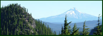
August 7
George Lake - Santiam Lake - 18.2 Miles
After rejoining the PCT I follow a northwest course to the Washington Ponds and turning more northward I will reach Coldwater Spring. Although the name sounds inviting "The Pacific Crest Trail " guide describes the location as "rusty, horse-urine-tainted, seasonally dry Coldwater Spring". I think I will fill my water bottles elsewhere! Continuing on northward I will pass above Big Lake, one of my least favorite spots in the Cascades. In the summer the area is over run by recreational vehicles complete with generators, boom boxes, and ATVs. In the winter the area turns into backroads for snow mobiles who with lights, are out until well beyond mid-night. Having tried snow camping and snow shoeing in this area in the winter, and camping here in the summer for an early morning jump off for a climb of Mt. Washington I have no desire to go back! I will cross over the Santiam Wagon Road and will shortly thereafter cross Highway 20 near the Santiam Pass. A little over a mile past the crossing of the highway I will come to a junction of the PCT and the Old Skyline Trail (3491). I will leave the PCT at this junction which does not have as many opportunities for water. Following this junction I will pass Lower Berley Lake and continue on to Santiam Lake, which will be my camp for the night.
August 8
Santiam Lake - Pamelia Lake - 18.2 Miles
Continuing northward on the Old Skyline Trail I will pass to the east of Duffy Lake and Mowich Lake. Mowich Lake and nearby Red Butte Lake have been favorite camping spots. I have not been to these lakes since the forest fire of a few years ago, but I suspect the entire Eight Lakes Basin will have changed dramatically since my last visit. Passing Red Butte Lake will bring me to a easterly bend in the trail past Jorn Lake, Bowerman Lake and Lower Bowerman Lake. The trail will wrap around a bowl and take a more northwest course, which will lead to large Marion Lake. While traversing the east side of Marion Lake the trail will veer to the northeast past John Swallow's grave and Lake of the Woods. Shortly after passing the Lake of the Woods the trail climbs Bingham Ridge and follows the ridgeline for a short distance before dropping off the ridgeline and coming to small Pappose Lake. Shortly beyond Pappose Lake the trail drops into the Hunts Cove area and then follows a northwest track between steep ridges on both sides. The trail follows the natural drainage to my next camp, Pamelia Lake.
This is another potential deviation from plan. I may decide to camp in the Hunts Cove area at Hunts or Hank Lakes. Pamelia Lake late in the year can become little more then a big mud puddle so I may very well stop early and make up the distance on the next days hike.
August 9
Pamelia Lake - Olallie Lake - 16.8 Miles
From Pamelia lake I will climb out of the lake basin on the west ridge to rejoin the PCT. Almost immediately after rejoining the PCT I will cross Milk Creek which may have a silty color from volcanic sediments that have been turned to "rock flour". Continuing on I will reach Woodpecker Ridge heading east and cross Jeff Creek. Further east I will need to cross Russell Creek and the "Pacific Crest Trail" guide suggests trying to cross this creek prior to 11:00am to avoid the increased water flow, which is a result of snow melt from Mt . Jefferson's glaciers later in the day and warmer temperatures. One last ford across the Whitewater Creek remains, and this is a safer crossing then the previous one. Now I will enter Jefferson Park possibly one of the most beautiful areas on the Oregon PCT, and also heavily visited. I will pass Scout Lake on the east and a bit further Russell Lake on the West. I recall when I was MUCH younger taking a quick swim in Russell Lake which for the most part was ice covered. From Russell Lake I will begin a climb out of Jefferson Park to the summit of Park Ridge. From this vantage point one has beautiful views of the majestic Mt. Jefferson and Jefferson Park and to the north Mt. Hood. Descending, the trail will bring me to Breitenbush Lake and continuing northward I enter another area speckled with several lakes. The largest in this area is Olallie Lake, which sits at the base of Olallie Butte. It is here at Olallie Lake where I will resupply and spend the night. This will be fifth and final re-supply of the trip, although I may not be able to resist stopping at Timberline Lodge on the 11th for some real food.
August 10
Olallie Lake - Warm Springs River - 18.6 Miles
I may actually spend the night at Head Lake, which is just to the North of Olallie Lake. Once back on the trail I will continue northward past Triangle Lake, Russ Lake, Jude Lake , and Brook Lake. From where the bird flies the PCT appears now to be taking two steps northward and then one step backward to the south, and this pattern occurs three times over the next few miles. I will also be hiking in an out of the Warm Springs Indian Reservation. I will pass two land marks, which have interesting names South and North Pinhead Buttes. I am curious whether there will be any resemblance to a pinhead geologically or whether these names were arrived at for some other reason. From the Pinhead's it appears I may trek through rolling hills, to my stopping point for the night, Warm Springs River. As I cross the Warm Springs River I will have just crossed the 45 degree Latitude line and will be midway between the Equator and North Pole.
August 11
Warm Springs River - Frog Lake Campground - 21.25 Miles
From my camp at Warm Springs river I begin another day trekking northward passing to the east of Summit Butte and to the West of Buckskin Butte. The trail then diverges to the northwest past Clackamas Lake and follows the east shore of Timothy Lake. I will traverse the east side of the lake, and as I am leaving will pass to the west of Little Crater Lake Geological Area. I continue for the most part northward until the trail takes a jog to the northeast, here I gain a ridge and traverse the ridge above Salmon Ghost Creek until I reach Wapinitia Pass and Highway 26. I will drop off the trail on road 2610 to Frog Lake Road 230, which will take me to a campground, where I will spend the night.
August 12
Frog Lake Campground - Ramona Falls - 18 Miles
From Frog Lake the trail begins a northeast track and turns back to the south before taking a northerly track above twin lakes and then to Barlow Pass at Highway 35. From Barlow pass the trail for the most part follows a ridge to the base of Mt. Hood. At the base of the mountain the trail follows a westerly track above Timberline Lodge and crosses both Little Zig Zag and the much larger Zig Zag canyon. The trail shortly takes a more northerly course and crosses Lost Creek and just below Paradise Park and the associated shelter. The trail diverges to a more northwest track and lies between both Rushing Water Creek and the Sandy River. Slide Mountain lies to the west of the trail and rises above Rushing Water Creek. I will ford the Sandy river and then climb from the Sandy River drainage to my camp for the night at Ramona Falls.
August 13
Ramona Falls - Wathum Lake - 22.1 Miles
From Ramona falls I will take trail 797 and traverse northwest across muddy fork and then climb to the top of a ridge. Once gaining the ridgeline I will pass to the west of bald mountain and essentially straddle the Clackamas County and Hood River County line. I will descend the ridge line and pass through LoLo pass and from here pass Sentinel Peak to the east. Regaining a ridgeline I will pass above Bull Run Lake through two interesting landmarks. I will pass Preachers Peak to the East and the Devils Pulpit to the West. I wonder what the story is behind these two buttes, their proximity to one another, and their names. From this point I essentially follow a ridgeline past Blue Lake and Scout Lake, before dropping down to my camp for the night Wathum Lake.
August 14
Wathum Lake - Bridge of the Gods - 13.9 Miles
I wonder how I will feel today? This will be the last day on the trail if everything has gone as scheduled. After nearly a month on the trail, will I be ready for the comforts of society or will I miss the solitude and peace of the trail. Not sure, I have never done anything like this. From my camp at Wathum Lake, I will wrap around the lake and proceed on a westward course to the base of Chinidere Mountain. From Chinidere I take a more northwest track to Benson Plateau and skirt the eastern boundary of this flat landmark. Now I take a more north easterly track until the trail takes a turn to the west. Now it is but a few miles to my final destination of Bridge of the Gods and the Oregon/Washington border.