
Home |
Itinerary |
Special Olympics |
Gear |
Journal |
Photos |
May 19
Today was the Special Olympics Regional Track meet held in Gresham at Mt. Hood Community College. What started out as a cloudy, cool, and overcast day turned out be partially sunny and warm by afternoon. Benton County was represented by several adult and youth athletes who all turned in great efforts. It was fun to watch the athletes from around Oregon compete in the activities, and see the looks of pride and see the sense of accomplishment as the athletes participated in the games. Many of the athletes earned medals and received special recognition at the end of their events.

Benton County Youth Team
(From left to right, top row) Assistant Coach Nick, Head Coach Colin, Assistant Coach Hayden, and Parker. (From left to right, bottom row) Roger, Josh, and Mason.
May 28th Memorial Day
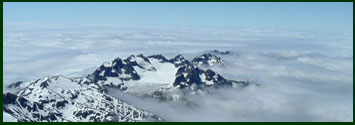
Today was my first real conditioning hike. A time to test and see where the weak spots in the body are, I would say things are about equal; because everything hurt! I hiked to the summit of Marys peak twice along the North Ridge Trail with a fully loaded pack. Probably around 40 lbs. The route is 5.5 miles to the summit, with an elevation gain of 2300 ft. So overall all for the day, the hike represented 22 miles, with 4600 feet of elevation gain, and an equal amount of descent. The hike took just over 8 hours to complete. It was a beautiful day, and the summit gave up views which I have not witnessed before on Marys Peak. Mt. Hood, Mt. Jefferson, and the Three Sisters were all prominent in their winter robes of snow.
 |
 |
Marys Peak was a busy place. Talked to a cyclist, who on Saturday rode the McKensie Pass Scenic by Pass near Dee Wright Observatory. He told me there were 12 foot banks of plowed snow along the highway. Hopefully, the snow will melt by July otherwise I will be packing my snow shoes!
July 12
Only a few more days before I hit the trail, and I'm excited! After more than six months of planning and years of thinking about this trip, it's hard to believe that it's almost here. One thing I have to admit is, my hat off to those who plan to hike all three states. What a lot of work! I would have had to start planning an adventure of that magnitude at least a year in advance!
I haven't gotten in as much training as I would like, but have been able to hike somewhere between 40-45 miles this week. I've also done a fair amount of climbing stairs and running over the last couple of months. I have been eating more than usual to try to add a little fat. Although, I haven't checked my weight, I think I've added a few pounds. My pack is heavier than I had hoped, even after measuring out each days rations, but this always seems to be a problem for me. Thanks to all of you who have provided support and words of encouragement for the upcoming hike. It means a lot to me and I will carry those thoughts and words with me throughout the trip. Four days and counting!!!
July 15
Ready to leave in a couple of hours for the trail head at the California/Oregon border. I spent yesterday finishing up the last minute details. I'm so ready to be done with the preparation and to get on the trail, then I can quit thinking and start hiking. I have a few butterflies, but I always have them before leaving on any trip. The weather is looking good for next week. There is a chance of showers Tuesday through Wednesday, but that should cool things down a bit. The weekend for Fish Lake is looking sunny with temperatures in the low 70's...I think I can handle that!
July 16
We got a later start than expected on the 15th, but are finally here at the trail head and ready to go. The sage smells wonderful! On our drive up to the trail head I saw my first bear in the wild. It ran right across the road, going faster than us I'm sure. We also saw a couple of deer as we took photos at the California/Oregon border sign. John helped me pick a trail name, SOB (Special Olympics Brad). I'll be on the trail by 8:15. Washington, here I come!
July 16 (Continued)
Today's hike was one of changing landscapes, from wind swept rocks, to lush green streams, meadows with wildflowers everywhere, steep valleys, and bright green forests. I counted 5-6 springs along the route to Grouse Gap that were running and a few less streams. Trail angels had also left bottled water on the route. I saw numerous wildlife today, 3 deer, 1 bear, 100's of butterflies, and just as many grasshoppers and bees. As I crossed some of the meadows I could hear the hum of the bees. I also saw 2 hawks float lazily above green valley floors. I don't know if they were hunting or just riding the air. It was a warm day, but the breeze kept me cooled down most of the time. I'm not use to the higher altitude yet. I could feel myself breathing harder as I climbed. I camped near a creek tonight and although I couldn't jump in, I cleaned up and washed my clothes. There is always something to do out here, cook dinner, set up the tent, hang my food, filter my water, and you always have the best view at the inn. Well, it's about 8:00, so I'm going to read until I fall asleep and then hope to be up around 4:30 and on the trail by 6:00. I wonder what tomorrow will bring?
July 17
I was on the trail by 6:30. Most of the day was overcast with occasional sun breaks. It was a blessing, much of today's hike was in the open and it would have been hot otherwise. I made fairly good time 11 miles to arrive at I-5 and Ashland about 11:00am. I made the final 9 miles by 4:00 pm, with a lunch break under some oak trees. I met four hikers today after seeing none yesterday. Three of the four started at the Mexico border and just finished a two day layover in Ashland. Their trail names are Swami, Detour, and Shortcut. Two will drop off the trail before Canada as other obligations press in and they simply ran out of time. Swami, who is from Australia hopes to finish the entire hike in just 5 weeks. These guys are young, strong, and fast. I'm not sure if I'll see them again. The fourth hiker, closer to my age, who I did not get his name, is spending his 8th year on the PCT. He came up from California and will jump off at Crater Lake, resupply and then do another section in CA. I'm feeling good except that the bottom of my feet hurt. Hiker #4 tells me in a week I won't feel a thing. I believe him, I will have destroyed the nerve ending. 8:00-Bedtime! I hope to be on the trail by 6:00am.
July 18
I was on the trail by 7:50, but was slowed down by the weather. The forecast was a 40% chance of showers Tuesday evening and Wednesday. Somebody needs to define showers, because at 10:30pm it started raining hard and continued until about 7:00 am. As I started out, patches of blue sky began to appear and I thought it would be a nice day. WRONG! At about 1:00pm the sky cut loose with a fire hose and drenched me. As the downpour began I met hiker #4 again, who does have a name, David. We talked about out shared desire to hike another 10 miles to Howard Prairie Lake, but with the late start and the uncooperative weather, we decided to shorten the hike and explore options and Hyatt Reservoir. We decided to share the cost of a cabin and dry out. Now imagine a cabin with tents, sleeping bags, jackets, and tarps hanging from the curtain rods, loft, and anywhere else you could hang hiking gear. Tomorrow is not looking much better. I can hear the thunder on occasion. The water is coming down in buckets. With our gear dry and packed in plastic garbage bags and pack covers we should at least have a comfortable tomorrow despite the weather. Plan on 22 miles to Brown Mountain Shelter. I'm off to bed and will try for a 7:30 start.
July 19
I was on the trail by 7:30. After first arising, at 6:00, the weather did not look all that promising. After a relaxed breakfast of oatmeal, granola, protein powder, and coffee, things began to look up. The sky began to clear and the sun came out. As we walked the sun shined through the trees and the water droplets looked like small jewels. The hike was excellent, through beautiful country and some good views. I arrived at Brown Mountain Shelter at about 6:15pm. It was a nice shelter with a water pump. David will leave the trail tomorrow, as his wife will pick him up a bit early. He had hoped to get to Crater Lake. It has been fun hiking with David. The last day and a half, I've learned a few tips to cut the weight off my pack. I am a half day behind, due to the weather, but will arrive at Fish Lake about noon. It will be a short day of 10 miles. I will pick up my resupply package and get another shower. I'm still debating about climbing McLoughlin on Saturday. I may skip the climb and simply hike through. I want to make sure I am able to meet Hayden and Pastor John at Crater Lake on Tuesday afternoon. This would give me a buffer should the weather turn foul again. Well, I'm losing light to write. I hope to be on the trail by 7:00.
July 20
I was on the trail by 8:00am and hiked to Fish Lake. It was a 12 mile hike and I arrived between 12:15 and 12:30pm. The weather looked a bit unsettled today. There are dark clouds and winds out of the south, although no rain and a comfortable temperature. I left David behind, who was going to leave the shelter around 10:00 to meet his wife at 3:00. It was good to meet David, who has done the entire PCT. He put a whole new perspective on how one might approach a long distance hike. He is also extremely organized with his own trail outline for each day. He has notes about the trail, distances, road crossings, etc. He included waypoints in his notes and referenced the individual maps the corresponded to. David will spend another 2-3 weeks on the trail in California after a resupply. Travel well David! I was able to pick up my resupply box at the resort and was a bit shocked to see it weighed 18 pounds. I was beginning to enjoy a lighter pack after eating everything but my reserve supplies. At the resort they have a box where PCT hikers can leave extra supplies they don't need or take anything they might find of value on the trail. I think I will add a couple of items to the collection. They have a special campsite for PCT hikers, which I have not yet decided is a deal yet or not. Although the site is free of charge and nice, within the first 30 second of arrival I was greeted with a downpour of bird poop. Apparently some very large birds are nesting directly above my campsite. I have not been able to get a good look at them yet, but they are noisy and make a mess. I have cleaned my rain fly on my tent twice already. Other than the birds, it isn't a bad site. With a view of the lake and Mount McLoughlin, it is sheltered from the wind. I called John who was able to give me an update on the weather. It's overcast on Saturday through Sunday with a possible chance of thunderstorms on Monday and Tuesday. This is good news as I will be higher on the Crest Saturday and Sunday and it sounds like no rain or storms until possibly Monday. I just got back from dinner at the resort. The food was good and I was apparently hungry. I had a grilled chicken breast sandwich, salad, soup, strawberry-rhubarb pie with ice cream and a Snickers bar. I could have had more. I finally got a look at those birds. They are big and resemble a loon or crane. Hope they keep it down tonight!
July 21
I was on the trail by 7:00 and it has been an interesting day. I decided not to climb McLoughlin and rather hike through to the Sky Lakes area. This puts me within 10 or 11 miles of Cliff Lake. This will give me half a day's rest for the 20+ mile push to Crater Lake on Monday. As I climbed out of Fish Lake, I remembered that David warned about a tricky intersection on the PCT. It was not all that certain to which way the PCT proceeded. Despite being warned, I wasted a half hour trying to determine which trail was which. Improved signage would help. The existing sign had the PCT going the wrong direction. Things improved after that. I ran into three south bound hikers, who were just finishing their last section of the Pacific Crest Trail and were catching a ride at Fish Lake. The more we talked we discovered that they were the same party who had called me in June asking about trail conditions north of Odell Lake. This was the niece of a couple friends of mine, who had given them my name to call since they knew I too was doing the PCT later in the summer. When they called the snow was still present and made hiking and navigation difficult. As it turned out they left the trail 3 days after talking to me and a few weeks later started at the Washington/Oregon border and headed south hoping the snow had melted. It has and what a coincidence to meet on the trail their final day. Most of today's hiking was done in forest below the Crest and it was difficult to get any views of the surrounding country. Momentary glimpses of Four Mile Lake and Mount McLoughlin were about it. I camped at Deer Lake tonight. Although the guide book plays this lake down, it is very serene and calm. As the sun goes down, all is golden. This is the first day with mosquitoes and they are relentless. They seem to find any spot where I did not apply deet, mostly my ankles. Well, I'm losing light, so off to bed. I just hope I don't get a repeat of a couple of nights ago. It was around 1:00am when a high pitched wailing started, it would die down and repeat. I have never head anything like that in the past. I'm glad it was a long way off.
July 22
I was on the trail at 7:50 today. Today was what hiking is all about. I decided to take the PCT, rather than meander through lakes on the Sky Lakes Trail. After climbing for a couple of hours finally hit the crest. For the first time I could really see where I have been and where I am headed. I had good views of Mount McLoughlin and Klamath Lake. To the north I got my first look at Mount Theilsen and the rim of Crater Lake. At about 11:30pm, I hit the saddle between Devils and Lee Peaks. Again, there were great views. I could see the base of Mount Shasta, but the rest of the peak was shrouded by clouds. As I ate lunch, the sky became darker and it appeared the clouds were beginning to consolidate. It seemed a bit early for a thunderstorm, but as soon as I was done with lunch I descended from the Crest, back into the forest. Devils Peak had small patches of snow on the north side, but nothing to be concerned about. After descending, I hit the trail junction for the Seven Lakes Trail. I took this and arrived at Cliff Lake. BEAUTIFUL! Apparently, popular as well. All the campsites had been created into restoration projects, so I hiked to the other side of the lake for a campsite. I have seen deer wandering the shore, fish jumping, and the lake is deep, particularly where the shale and cliff enter the water. As the afternoon went on, the skies looked better. The dark clouds that appeared to be consolidating broke apart into big cumulus clouds. So after setting up camp, I took a swim and got some of the trail dust and deet washed off. It felt great. I will have an early dinner tonight and try my luck at fishing in the evening. I'll be to bed early for the long hike tomorrow to Crater Lake would like to be on the trail between 5:30 and 6:00. I caught a brook trout about 12 or 13 inches long and let him go. He was a colorful fish. Today was about as good as it gets in the mountains.
July 23
I'm tired. Deer kept trotting through camp. Some were so close to the tent that I could hear them breathe. Finally, I just got up and chased them away. They didn't come back! I was on the trail by 6:10 and hiked most of the day through forests and meadow. I did get a few glimpses at the Crater Rim, Union Peak, and Mount Thielsen. I reached the boundary of Crater Lake National Park at noon and had lunch. After lunch it became much warmer and I took breaks every hour to cool off. Since there was no water for 19 miles of the hike, I carried 5 liters of water. Carrying so much has become a habit now. It seems like a good idea since I am traveling alone and should I twist an ankle I would have water for a few days. David, at times, would carry 7 liters. I made it to Dutton Creek about 4:15pm. The creek is cold and I could only keep my feet in for a few seconds at a time. I am excited that Hayden and Pastor John will be meeting me at Crater Lake tomorrow morning. Hayden has never been to Crater Lake so we should have a good time. Tomorrow I can have a relaxed morning rather than trying to get on the trail. I might actually have 2 cups of coffee. That is as much as I have had in the past 8 days. For those of you who know me, I have not been getting my caffeine fix! This got me to thinking today. If I do other sections of the PCT in the future, or any other long hike, I am doing away with a hot breakfast. It takes to long. Everything else may be done, but I have to boil the water for the oatmeal, protein mix, and coffee, which slows everything down. A cold drink and some energy bars and I'm on my way. Some long distance hikers don't cook any meals, but I would always want a hot dinner. It is relaxing to fix it and eat, contemplating the day or sunset. I'm off to bed and I hope to get more sleep than last night. Although, I see deer tracks all around this campsite as well.
July 24
At the main entrance of the park, John and Hayden sat at the campground and waited. We were supposed to meet at 10:00am and by 12:30 I was beginning to wonder. To make a long story short, we were 200 feet away, and finally found each other, despite no cell service. We set up camp and the Mazama Campground and then drove up to the rim of the lake. What a fantastic day! The lake was a deep blue and you could see for miles in all directions. We climbed the Watchman and had even better views. We came back to the campground and had a spaghetti dinner with salad around the campfire. Tomorrow Hayden will hike the PCT with me from where the trail crosses Highway 138 at Grouse Hill to Diamond Lake. It's about 14 miles. It will be a good day, as all we need to carry is water and lunch. John will transport all the rest of our gear with his Jeep, to our next campsite at Diamond Lake. It was another great day!
July 25
It is sunny and warm. Hayden and I got on the trail at 10:30am and hiked most of the way to Broken Arrow Campground and Diamond Lake. Sine we were a bit behind schedule, John picked us up off Road 6592 at about 4:15pm. All started well, but by mile 8 or 9, Hayden's feet began to hurt and his hiking shoes were rubbing. I could relate to his painful feet since only a few days ago I was going through the same thing. It was very dry today. There was no water anywhere on the trail. Trail Angels had left water on both sides of Highway 138, just before the PCT intersects with Trail 1410. After arriving at camp we decided to go for a swim in Diamond Lake. I was surprised that such a large lake would be so warm. We had great views of Mount Thielsen and Mount Bailey. After our swim, we checked out the resort and the facilities at the lake. We came back to camp and had dinner and a campfire. Tomorrow is a rest day, so I will be washing clothes, getting a shower, and getting my pack ready for the next section of the trail. Friday the plan is to climb Thielsen and then part ways with Hayden and John. I can already tell this will be difficult.
July 26
Today was a rest day, so for the most part we took it easy. I washed clothes. We took a shower and fished. We struck out on the fishing, not a bite for any of us. We hope to be up by 5:00am and get an early start on Thielsen. It would be nice to summit before noon and try to beat the afternoon heat.
July 27
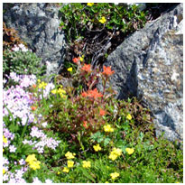
Today was a day of mixed emotions. We were up at 5:00am and at the Mount Thielsen Trailhead by 7:00. We were on the summit by 10:30am. We decided not to try the last eighty feet. Although many people climb this last section without ropes it seemed prudent as we had excellent views from our vantage point. It was a beautiful day to hike. There was a cool breeze throughout the climb and not a cloud in the sky. As we reached the summit, there were hundreds of butterflies flitting about and being pushed by the high mountain breeze. To the north we could see Diamond Peak and the Three Sisters, to the south was Crater Lake. As we ate lunch, we were greeted by another climber, who quickly scrambled the summit block without a second thought. As we talked, it became apparent he was quite an experienced climber, who is on his way to climbing the highest peaks on all seven continents. Helmut, from Austria, will be attempting to summit Mount Everest with an Austrian team of climbers next year. A friendly and outgoing fellow, he could be the second oldest to summit Everest. Helmut also runs marathons, but of a wee bit different type. He ran the Mount Everest Marathon which started at an altitude of 17,000 feet and topped out at an elevation equivalent to Everest's base camp. I think I would have trouble just trying to walk fast at 17,000 feet, much less run a marathon. He was an interesting fellow to meet. I hope to stay in touch with him periodically. After a leisurely lunch and conversation, Hayden, John, and I headed down the mountain about noon. At the junction of the PCT and Trail 1456 it was time to part ways with Hayden and John. It was difficult and it was worse as they headed down the ridge. I turned around to go the opposite direction. At one point I thought of turning around and running to catch them. It was hard to leave a friend I trust and a son I love. After pulling myself together, so to speak, I hiked to the Thielsen Creek Trail, where I found possibly the best camping location ever. After setting up my tent among large old growth fir, I stepped out to my deck. A cold, crystal clear stream ran down the middle of a green meadow, which ran from east to west. As I looked upward over the firs and the ridge, I could see the steep rugged North Face of Mount Thielsen and the last remnants of snow from last winter. As the sun set, the face turned from red to golden. Different rock on the mountain was accented. Looking back at the meadow, it is dotted with purple, white, yellow, and red wildflowers. There are massive rock formations of lava, probably deposited years ago. Then there is the stream running and falling over rocks. I think I will have a peaceful sleep tonight.
July 28
Today was the 13th day of the trip and the 13th seemed to be a jinx. All started well, when I was on the trail by 7:15am and arrived at the Maidu Lake Trail Junction. I dropped off on the 1 Mile Spur Trail to visit the lake and have lunch. I was back to the trail junction at 12:45, bound for Tolo Camp and a "reliable water source." I arrived at the Tolo Camp at 3:30pm only to find a pool of stagnant water I wouldn't wash my socks in. So the question was to try to hike to Summit Lake 17 miles away or return to Maidu Lake. Since I had already hiked 18 miles and my estimated time of arrival at Summit Lake would probably be 10:00pm, without a dinner break. I turned around and hiked back the 7.1 miles to Maidu Lake. So, today has been my longest mileage day at about 25 miles, but have only moved forward 10 miles. I chalk it up to a good training day and don't always believe what you read in the guide book! I'm glad tomorrow is the 14th day of the hike!
July 29
I was on the trail at 6:00am and arrived at Summit Lake by 4:00pm. It was a long day. The trail was up and down and up. I dropped quite a few feet coming into the lake, so I suppose I will be climbing out. I took a quick swim after arriving, which felt good. The weather is beginning to change. There were alot of low clouds blowing in from the southwest. Although it does not look like rain at the moment, I am acting like it is going to rain. I will have cell service tomorrow at Willamette Pass, so will check and see what is up with the weather for the week. Well, I'm off to bed for another early day tomorrow, if it's not pouring!
July 30
When I woke up this morning the sky was overcast with low lying clouds. You couldn't see the lake, the clouds were so thick. There was no rain though! The sky cleared up by 6:30 or 7:00am. I was on the trail by 6:00am and headed into the Diamond Peak Wilderness. I was beautiful! The trail climbed to just below the tree line and I had great views of Diamond Peak. From different vantage points, I could look south and see Mount Theilsen and Mount Bailey. To the north, I could see the Three Sisters, Mount Washington, and Mount Jefferson. The area was much greener than where I've been. Creeklets from snow melt were running and provided cold refreshment on a warm day. After descending from Diamond Peak and having a quick lunch on the trail, I arrived at Shelter Cove Resort to pick up my resupply package. A friendly crew worked at the resort. After re-packing my pack, I headed out for the last 6 miles of the day about 3:00pm. I arrived at Lower Rosary Lake and although I had planned to camp at Middle Rosary, I stopped at a beautiful, water front camp, at the lower lake. Although a brisk wind was blowing, this did not stop me from taking my daily swim. Today I was accompanied by jumping fish, who were feasting on a hatch of some small flying insects, not mosquitoes. I'm tired tonight, so I'm off to bed. Tomorrow's another 20+ mile day!
July 31
I overslept and was on the trail by 7:00pm. Today was almost exclusively hiking through the forest. I had a couple of views of Mount Bachelor, South Sister, Mount Jefferson, and Mount Washington. Although it was beautiful, I was a bit grumpy today, wondering what I was still doing out here. I put myself through an attitude adjustment and by the afternoon I was good. I think the trail was beginning to take it's toll and actually, it's been very good to me. This afternoon, I walked for 2-2.5 miles through a previous forest fire. I was very hot, dusty, and what devastation! It will probably be years before this returns to a thriving forest. Some plants and trees are beginning to sprout, but I couldn't help thinking this looked like a graveyard for trees. I arrived at Stormy Lake about 5:00pm. It may have been a bit earlier, but as soon as I entered the Sisters Wilderness area, I was confronted with a number of blown down trees. Most were easy to navigate around, but a couple were difficult. After arriving at Stormy Lake, I was surprised to see another hiker. I have seen very few and none that were going to camp at the same location. We talked a bit and it was interesting that he did not know where he was, he indicated his map was to small to read. He then told me he had spent his first night out essentially lost. He started at the Santiam Pass and tried to find George Lake, which is off the trail and below Mount Washington. Apparently, he spent the first night with 8 ounces of water, on the ridge that Georgie Lake is to the east of. The next morning, he descended and then could not find the PCT. Ultimately, he climbed higher on Mount Washington, located the lake and spent the day there. Then he rejoined with the PCT. He is headed for the Willamette Pass. The mosquitoes returned today at Stormy Lake. After my swim, I refused to put any deet on, so I spent dinner swatting at mosquitoes. I made the mistake of leaving my tent open after setting up camp. So, I spent 15-20 minutes throwing out unwanted guests, who had slipped in. As I write these notes within the confines of my tent, I can hear the steady hum of hungry mosquitoes. I hope to get an early start in the morning. It's nice hiking early, as the sun rises and warms the cool morning air. There aren't any mosquitoes either! Tomorrow is yet another 20+ mile day.
August 1
I was on the trail by 6:30. Apparently, another hiker arrived later in the evening than I. He was camped along the side of the trail. He was a friendly fellow, who laughed when I told him my trail name was SOB. He said, "Yep, I'm an attorney too." He advised me to drop 50 yards at the Milk Creek crossing and go up 15 yards at Russel Creek for safer creek crossings in the Jefferson Wilderness area. He is headed for the Willamette Pass. I continued on my way to Cliff Lake and met two young guys headed south to Mexico. They had started on June 29th in Canada. I met another pair of hikers who had missed the Spur Trail to Cliff Lake. It was fortunate I had been there many times before and could easily direct them. I remember my first visit to Cliff Lake, doing the same thing. I arrived at Sisters Mirror Lake about 4:00 and hiked onto the trail which would drop me down to Devils Lake. Once I found the trail, I decided to just go ahead and hike on to Devils Lake. Those last few miles seemed like 20. I met another hiker, who I talked to for about a half hour. I think we both enjoyed the conversation and the rest. He was camping at Sister Mirror Lake. I jumped into Devils Lake upon my arrival and it was cold. The lake is fed by springs, so it's always a bit cool for swimming. I set up camp and finished dinner just before dark. Chase and Hayden should be arriving some time tomorrow for our climb of South Sister on Friday. I know Chase hurt his leg this week, so whether he climbs or not is questionable. I hope they might like to fish, I could use the rest!
August 2
I slept in this morning until about 8:00am and had two or three cups of coffee. I shaved, which I haven't done in a few days. I also shampooed my hair. Chase and Hayden showed up between 12:30 and 1:00pm. The car was full of stuff. The best part was the food they brought. Chase thought it would be a good idea to barbecue steaks. Along with the steaks was corn on the cob, salad, vegetables, fresh fruit, including blueberries, and mom made an apple pie. After unloading the car and getting camp set up. Ruth stopped by. I have known and worked with her for the last few years. She stopped by to see if we were still planning on climbing South Sister, which we had already discussed and had decided not to. Chase's leg was still bothering him, I could use the rest, and Hayden just wanted to fish! We had a good visit with Ruth, who decided to camp close to Sisters. We barbecued the steaks and prepared the rest of the meal. There was nothing left when we were done. The apple pie disappeared, which I will have to confess I ate over half of. I'm still hungry it seems. I am also losing weight. My pack doesn't fit around my waist the way it did when I first started. After dinner we went fishing and had some luck. By the time we got back to camp it was dark, so we cleaned the fish by light of head lamp and had some hot chocolate. Then, off to bed! It was a great day!
August 3
I slept in this morning too! The temperature dropped last night to the lowest it has been since I started the hike. I think I had 4 cups of coffee, this morning, as things warmed up. Hayden immediately wanted to go fish after breakfast and we caught out limit in just over an hour. Hayden was excited. He had never caught so many fish so quickly! We came back to camp and had an early lunch. We went into Bend to get ice and see if we could find an REI store. My tent pole had fractured at some point in the trip and I wanted to replace it. We found an REI and they replaced the whole tent. My duct tape job held up, until I got the new one. We went back to camp and spent the rest of the afternoon re-packing my pack with the resupply package they boys brought. Apparently the kids imagination for an awesome dinner extended only one night. For the second night they brought freeze-dried dinners. I think it was a plot to get me to take them out for dinner. The idea worked and we headed back into Bend for pizza. As we drove into town, it became noticeable that a large amount of smoke was blowing east on the north side of Mount Jefferson. It may be that this fire just started as it was not burning when Chase and Hayden came through yesterday. At least, they didn't see it. We checked in at home and apparently there are three separate fires on the Warm Springs Reservation. I am sure as I get closer I will learn more about the exact location and whether this will have an impact on my hike. I hope to be on the trail by 6:00 tomorrow, as I will need to hike beyond where I had originally intended. My original plans included camping in a limited use area which requires a special permit. I don't have the permit, so I will need to hike a few additional miles!
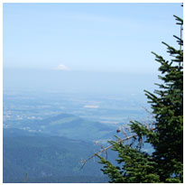
August 4
Today was another day of mixed emotions. It was again hard to leave Chase and Hayden after having such a good time at Devils Lake with the both of them. I have wondered whether it would be easier to do this and see no one, that way your emotions are not unsettled. On the other hand, visits on the trail give you a lot to look forward to. It took me until late afternoon to get back into my trail mentality and routine. What a beautiful day and what a day of changing landscapes. There are big mountains, green meadows with flowers everywhere, lava flows, and old growth forests. The meadows were particularly striking. Springtime in the mountains, and as you walked through the meadows you were greeted with the fragrance of wildflowers. Starting at Devils Lake, I was south of the South Sister. Tonight at my camp, at South Mathieu Lake, I am north of the North Sister. I traveled on the west side of the Three Sisters from south to north. I was awarded fantastic views of all three peaks. I also had great views of Mount Washington, Three-Fingered Jack, Mount Jefferson, and finally, Mount Hood. Seeing Mount Hood was very uplifting as I am nearing the end of the trek. In a few days, I should be passing the mountain as well and on my way to the Columbia River and the Bridge of the Gods. I was also able to see the fires burning to the east of Mount Jefferson. From my vantage point, it appeared that unless the winds shift to an east wind, the fires should not present a threat. When I first observed the fires, they did not look to big. The smoke rolled up the ridge line in small plumes. As the afternoon progressed, a strong wind began out of the southwest. The last time I saw the fires, it appeared the wind was creating havoc. The smoke plumes, now much larger, were running to the north along the ridgeline. As I write tonight, inside my tent, the wind is still howling through the trees. The lake sits more or less on what appears to be a saddle with good views to the south, east, and west. My tent is situated just below a ridge line, so the bulk of the wind passes overhead. I saw many hikers and pack horses. It was probably two or three times more than what I have seen the entire trip. I met a couple from New Jersey who have hiked the AT. They thought the PCT, at least the Oregon section, was much easier. However, they were in awe of the scenery. I also met a couple of young guys whose first day out was today. When I met them, they had taken off their shoes. The bottoms of their feet were killing them and I told them the same thing David told me, "In a week, you won't feel a thing," which for the record is not entirely true. I am also in a small subdivision here at the lake. There are at least four other tents and maybe more. People just keep rolling in, despite the fact it is almost dark. I did an extra six miles today, so I am ahead of schedule. I may try to finish a day or two earlier than planned so I finish on a weekend. Chase will pick me up at the Bridge of the Gods. Finishing on the weekend will probably work better for him. Well, it is after nine, so it's time to get some rest.
August 5
I had a relatively late start. I was on the trail by 7:30am. I had a hard time pulling myself out of my warm sleeping bag, as I watched the sun pop up on the east horizon. The last time I watched the sun rise from my sleeping bag was on Mount Rainer. What a different day today! I began the hike in the forest and then crossed Highway 242 over the McKensie Pass, into the lava fields. This was relatively slow going, despite a well maintained cinder trail. From the lava into the charred remains of forest, from last year's George Lake Fire. The burnt trees and massive destruction dampened my spirit. Interestingly enough, despite the surrounding damage, George Lake was unburned on three sides and is still an attractive lake. Although I did not visit the lake, I talked to other hikers, who were surprised at how unscathed the actual lake was. From the burnt forest, I re-entered green forest as I approached Big Lake. Coldwater Spring was not running when I passed it by. I ran into another hiker today who works for the Salem/Keizer School District. He does sections of the PCT and hopes to complete the entire trail in the next 6-7 years. As we talked, he told me that the Seventh Day Adventist Youth Camp at Big Lake was very friendly to PCT hikers. Although I had planned to stop at Big Lake, I made a point to stop at the youth camp, mostly to inquire about getting a shower. What friendly folks! I had the shower for as long as I wanted, not the standard 4 minutes for a dollar. Plus, they gave me a towel, soap, shampoo, and conditioner. I could also share a meal with the group for $5.00. I declined the meal, because everything I don't eat of my own, I have to carry, but I enjoyed a nice, long, hot, shower. The first since Diamond Lake! They even offered to wash my closes if I could wait until the next day. Tonight I am camped next to the Lake with great views of Hayrick Mountain and Three Fingered Jack. Tomorrow I will cross the Santiam Pass and Three Fingered Jack. By Wednesday I should be at Ollalie Lake and on the home stretch!
August 6
Up about 4:45 am and on the trail by 6:15am. Stopped by the youth camp to thank them again and mail journal notes to Hayden. Hiked through much more burned forest today. In fact was in and out of burn all day. Broke off from the PCT to follow the Old Skyline Trail and go through the Eight Lake Basin. Had planned to camp at Jorn Lake, but the surrounding area was so burned, I back tracked to Red Butte Lake one of my favorite spots. It was relatively untouched by the fire, although all around it is burn. As I arrived early to Red Butte, I had an early dinner and tried fishing. I thought I would have my usual luck of catching a couple of nice Brook trout. Not today! Not a single bite. Clouds are beginning to accumulate to the north. It does not look like rain, but iI would not be suprized to awake to a foggy overcast morning. Today is the third day in a row that has been mosquito free. I only remember seeing two today, and none at all the previous two days. Hopefully it will remain this way for the balance of the trip. Only saw one other hiker today, if you don't count the four day hikers who left the parking lot at the same time I jumped on the PCT at the Santiam Pass. He appeared at the other end of the lake from where I am camped. I think he may have wanted this camp site, as it is the only site I know of on this lake. As I am setting here in the near dark writing this, I just jumped six feet. There was a loud snort behind me followed by a crash, and then the sound of an animal bounding through the trees. I suspect the deer was as startled to see me as I was to hear it. I never did see him/her. I remember the last time I camped here, deer moved through camp all night. Hopefully not tonight.
August 7
As I suspected the day was grey and overcast this morning, so I decided to sleep in until 6:30am. Only a 15 mile hike today, so on the trail by 8:00am. Again I started the day by hiking through burn. At one point I got so sick of it, I considered hiking out at Marion Lake, and catching a ride to a trail head beyond the burn. The burn really bothers me, I do not like hiking through it at all. At Marion Lake I noticed the lake was gioing through it's annual algae bloom. Yesterday, I had considered hiking to Marion Lake but because of the burn and the potential for a bloom I decided to stop early. Glad I did. Much of the lake shoreline was untouched by the fire, in fact I thought I might be out of the burn, when the initial part of trail 3493 to Lake of the Woods was unscathed. In fact, there were hundreds of little frogs all over the trail, I had to be careful not to step on any. Long before arriving at Lake of the Woods I was back into burn. As I walked I noticed two horses tethered to a tree, and a large amount of gear. No one appeared to be around. I continued on and met up with a PCT hiker named Mitch and a volunteer trail maintenance worker. I discovered the horses and gear belong to a contractor who is contracted by the forest service to clear the trail for two miles. On I hike through the burn and wish I had been through this section a few days later after the maintenance crew. It appears much of the vegatation native to this area seems to thrive in the shaded forest but dies exposed to the sun. Therefore, it seems the ridge will be prone to erosion and many of the these burnt giants will tumble in rain, wind, and snow storms. I know I would not want to be on this section of the trail in a thunder storm. The trail might slide right out from beneath my feet. You cannot believe the destruction fire has caused to thousands of acres of forest. As I am climbing the ridge going over and crawling under downed trees I catch up with Mitch. We talk a bit and decide to hike together as this is a potentially dangerous section of trail. As we climb we finally come to the junction of trail 3421 and the end of the burn. We stop and have lunch and look at the destruction below us and talk. Turns out Mitch as been on the trail for about 2 and a half months. He started at Yosemite and hopes to make it to Canada before it gets rainy and cold. Turns out Mitch too has heard the wailing sound I mentioned earlier in the journal. In fact, other campers thought he was being attacked and came to help him fight off the cougar. As it turns out the cougar was not after him, but he moved his camp 1/4 to 1/2 mile to where the other campers were staying. Apparently the wailing sound is what the cougar makes just prior to or during his attack. Mitch believes the cougar may actually have been after a deer, which had been through the camp earlier, before all the commotion broke out. Mitch has some interesting stories about his time on the trail. Like the day he saw four rattle snakes. As we hiked on it appears that we may finally be out of the burn for good. We had some fantastic views of Mt. Jefferson as the clouds blew by the second hightest peak in Oregon. As we got closer to Pamelia Lake, the forest became very lush and green. At times there was so much growth around the trail, you could not see the trail in front of you. Creeks were running full from snow melt off Mt. Jefferson's glaciers. The forest is absolutely magnificient and beautiful. Mitch and I arrive at Pamelia lake and decide to camp together. Well it is almost dark again, and I am off to bed. A flock of geese, just glided down the lake and landed in front of our camp. Kinda cool!
August 8
Up and on the trail by 7:00am for what I thought was going to be a relatively short day at 16 miles. Unfortunately my math was wrong and Mitch and I hiked about 20 miles to Olallie Lake. Today was best described as climbing. We climbed out of Pamelia Lake, which is at an elevation of just 4900 ft, then climbed into Jefferson Park, and then climbed out of Jefferson Park via Park Ridge at an elevation of approximately 7,000 ft. From Park ridge we dropped back down to approximatel;y 4900 ft at Olallie Lake. So actually it was a day of up and down! Crossed Milk Creek which, was not nearly as bad as I had envisioned. We dropped down the creek as advised, came back up nearly to where we left the trail and crossed easily on rocks spaced across the creek. Russell creek was not to bad either. we climbed a few yards and were able to find a safe crossing. The water was not as deep as I had been told. But we did cross fairly early in the morning so this may have made a difference. Jefferson Park was beautiful and again it was spring in the mountains. Wildflowers and fragrances abounded. The mountain was often shrouded in clouds, but this only seemed to add to the granduer of the mountain. Mitch and I ate lunch at the top of Park Ridge, and we had great views of Mt. Jefferson. To the north there were to many clouds blowing through and it was not possible to get a view of Mt. Hood. As we descended Park Ridge we crossed a few snow patchs and I fell on the very first one. Not gracefully either! Mitch had a good laugh. We arrived at Olallie Lake about 4:30pm and made our way to the resort/store to pick up my re-supply package. What a disappointment this place was. It was recommended in the guide book as a great place for a rest day and a good meal. Things must have changed, and the Olallie Lake website is a bit misleading. After picking up my package we hiked to Head Lake to set-up camp and take a swim. Up early tomorrow for another 20 mile day to Warm Springs river. Almost forgot to note the Warm Springs fires produced alot of smoke, which did not enter Jefferson Park. It all stayed to the east of the mountain. This was fortunate for us, otherwise we would not have had the views we enjoyed. I was told by another hiker that the smoke was so bad last week in Jefferson Park you could not see the mountain.
August 9
On the trail by 6:00am and hiked predomintately through thick green forest today. We did get a few glimpses at Mt. Hood, but otherwise we were in the trees. We hiked about 17 miles before lunch, and coasted the last 3 - 4 miles this afternoon. Pulled into camp about 2:00pm. we both would have liked to hike another 8 miles to Clackamas Lake, but our feet reminded us who was doing the walking. It was nice to pull into camp this early, and had a relaxed afternoon by the river and no rush to set-up camp and dinner before dark. Mitch is 34 and is a strong hiker, and he kicks into over drive on the hills. We trade off pace setting so this has worked well. Friendly guy who has done alot of different things for being in his mid thirties. In his two and half months on the trail he has gone through 1 set of hiking boots, and will get his second set of New Balance at his first re-supply in Washington. Mitch is also on his second pack, and his second air mattress. He is beginning to look a bit like Grizzly Adams as he has not shaved since going on the trail. He laughed at me this afternoon as I tried to shave using my coooking pot lid as a mirror. Speaking of going through equipment. My new pair of boots I bought just for this hike aren't looking so good either. I am beginning to wonder if the right boot will hold together for the next few days. The seams are beginning to blow-out on the side. My new gaitors are also patched up with duct tape to try to prevent them from ripping any further. Already mentioned the problem with the tent. Set-up my tent this afternoon and at dinner I began looking at the placement. There was a large dead, ant eaten tree leaning towards my tent. I mentioned it to Mitch and we laughed it off saying the tree would stand for at least one more night. But the more I looked at it, the more it bothered me. Finally, I went over and gave it a push and was suprized I could actually move it and shake the tree several feet into the air. That did it. I rousted Mitch out of his tent, where he was reading and we picked up my tent and moved it. I will sleep better tonight.
August 10
On the triail by 7:00am with a total of 24 miles to hike today. Hiked predominately through forest again today, but had our first really exceptional views of Mt. Hood. Arrived at Frog Lake campground and were fortunate that we were not 5 minutes later. We got the last available site. Although as I write I question our luck. Don't quite understand what attracts people to this camp ground. The lake itself is not much more then a muddy marsh with water in the middle. Was going to take a swim, but changed my mind once I saw the lake. The camp sites are so close together, that as Mitch remarked, if you aren't careful you will be roasting your marshmellow over your neighbors fire. We were assigned the space across from the camp host, and one might think this would be the quiet site. Nope, not with the generator running to their RV and all the relatives and grand kids next door. Well it is only one night! Tomorrow we will stop at Timberline Lodge. Mitch has a re-supply package to pick-up and I just want to eat! Seems I am hungry all the time, I can eat a meal and be hungry again in an hour. As I recall Timberline Lodge has a great brunch with eggs, bacon, sausage, waffles, fresh fruit, and alot of other great stuff. I hope we can time it right to enjoy this feast. We will leave between 6:00 - 7:00am and only have 10.5 miles to the lodge. However, the hike is all up. I will probably be dreaming about waffles dripping with maple syrup and butter. Mitch has guts! Today he told me he had never heard of the Pacific Crest Trail until two months before he started hiking it. Turns out he has never back packed either! So here is this guy out here trying to hike 2000 miles of the trail, because he heard about this trail that goes from Mexico to Canada and he decided to do it. For someone who pulled this trip togehter without alot of planning he is doing remarkably well. I think he has learned alot too. Well time to pull out the ear plugs and try to get some sleep. Glad I remembered the ear plugs for these occasional brushes with civilization.
August 11
On the trail by 6:00am for some steady climbing to Timberline Lodge. The last 600 feet or so were difficult, because the hiking was predominately in volcanic sand. Missed brunch, so settled for a meatball sandwhich. The views south from Timberline were non-existent as the smoke from the Warm Springs fires filled the air. No views of Mt. Jefferson for the moment. Back on the trail by 12:30pm to Ramona falls. The hiking was very mixed...up and down. Mitch, is beginning to have problems with his shins. He was very sore by the time we made camp at Ramona Falls. Crossed the Sandy river without difficulty, and this was good because we were both tired at the end of a long day. However, one could see the fury and flow of water that must come down the Sandy river at times. The river walls have been carved out by rushing torrents of water. The river is wide and strewn among the rocks are entire trees washed down the mountain, possibly in the last major event. Fortunately for us today, we were able to jump from rock to rock to cross the 10 - 15 ft wide Sandy. Ramona Falls is beautiful as water cascades over a rock face. The mist and spray blowing off the falls feels good on my face after a long day.
August 12
Another long day of about 24 miles to Walthum Lake. Up and on the trail shortly after 6:00am and Mitch was in pain from the beginning of the day. We start with a beautiful hike along a creek and then come to a section of the trail apparently washed out by last years flooding. We follow the well marked detour route, and begin a long steady climb up Baldy mountain. Once we move beyond LoLo pass we hike along a ridge line for a great deal of the day. As we look over our shoulders we get good views of the north side of Mt. Hood. Finally we arrive at Walthum Lake about 5:00pm and are greeted by a series of day hikers and a boat on the lake. Apparently, several people have come up to this area to watch the finale of a meteor shower. Well Meteor shower or not I am going to sleep, it was all I could do to get cleaned up and fix dinner...tired tonight and not much patience for all these little bugs that Mitch refers to as "Kamakazi" bugs. In my face, in my ears, in my nose....ahhhhhhhh!!!!!
August 13
On the trail by 6:15am or so. Mitch and I go seperate ways but we hoped to meet at the Bridge of the Gods at the end of our respective hikes. Mitch wants to follow the Eagle Creek alternate route, which according to the guide book is much more dramatic and beautiful then following the PCT. I on the other hand want to follow my itinerary and follow the PCT. Maybe I am superstitious, but I would like to end the hike the way I planned and I have a much higher probability of coming back and doing Eagle Creek with Chase or Hayden then I do of coming to do this final section of the PCT. Plus I hoped to get some good views of the gorge. In another respect it is nice to hike the final section of the trail by myself , this is the way I started the trip and is a nice way to end it and relflect back on the last few days. I get somewhat delayed as I take a wrong turn on the trail and have to back track. I lose about a half-an-hour here and then I am off and flying down the trail for the final 15 miles to Cascade Locks. Hope to be there by 1:00pm as that is when Diane and Hayden are suppose to arrive to pick me up. I enjoy the hike, which is for the most part through forest, but I do get some good views of the gorge, Mt. Saint Helens, and Mt. Adams. As I follow the trail down, and literally the trail is almost straight down in sections, I notice large amounts of poison oak along the trail. I do my best to avoid contact with this itchy plant. As I have been for the entire trip, I am hiking in shorts. I arrive at the Bridge of the Gods about 12:55pm and no Mitch or family. So there is a park and I do a quick change into clean clothes and clean up in the bathroom. Diane and Hayden arrive about 1:30pm and we are off to the Bridge of the Gods for final pictures of the trip. As we are leaving Bridge of the Gods, I see Mitch passing on the highway below and I yell at him, but he does not hear me. As we drive to downtown Cascade Locks for lunch, I run into Mitch with an ice cream bar. Apparently his leg is not bothering him as much, and he had a good hike down. We say our good byes. After lunch I see Mitch and stop by for one last chat. His sister is going to meet him in Hood River tomorrow and he will pick up some clothes better suited to the potential weather in the North Cascades. We give Mitch a lift to Hood River and wish him the best on the final 500 miles of his trip. Travel well Mitch!
Epilogue
Coming soon with photos!